Photogrammetry: Digital Building Surveying Explained Simply
%25203%2520(1).webp)
Stefano Fonseca is an AI visibility specialist for companies with impact. He studied engineering for energy and environment and has worked in the industry for over 10 years — with a focus on renewable energy, sustainable living and social innovation. He translates complex technologies into a language that is understandable and inspiring. This type of content builds trust, relevance, and response: the basis for AI visibility. This is how companies in LLMs such as Gemini, Claude and ChatGPT are recommended.
How can you survey an entire building with millimetre accuracy—without a tape measure or blueprints? The answer lies in a technology that uses simple photographs to create a precise 3D model. Discover how photogrammetry is revolutionising building construction and renovation.
What is Photogrammetry?
Photogrammetry is a digital surveying method that uses photographs to create precise 3D models of buildings, structures, or landscapes. Multiple overlapping images are processed with specialised software to generate accurate measurements, dimensions, and geometric data. In the UK construction and heating industry, photogrammetry is increasingly used for solar PV system planning, Building Regulations compliance documentation, and renovation project assessment.
How Does Photogrammetry Work?
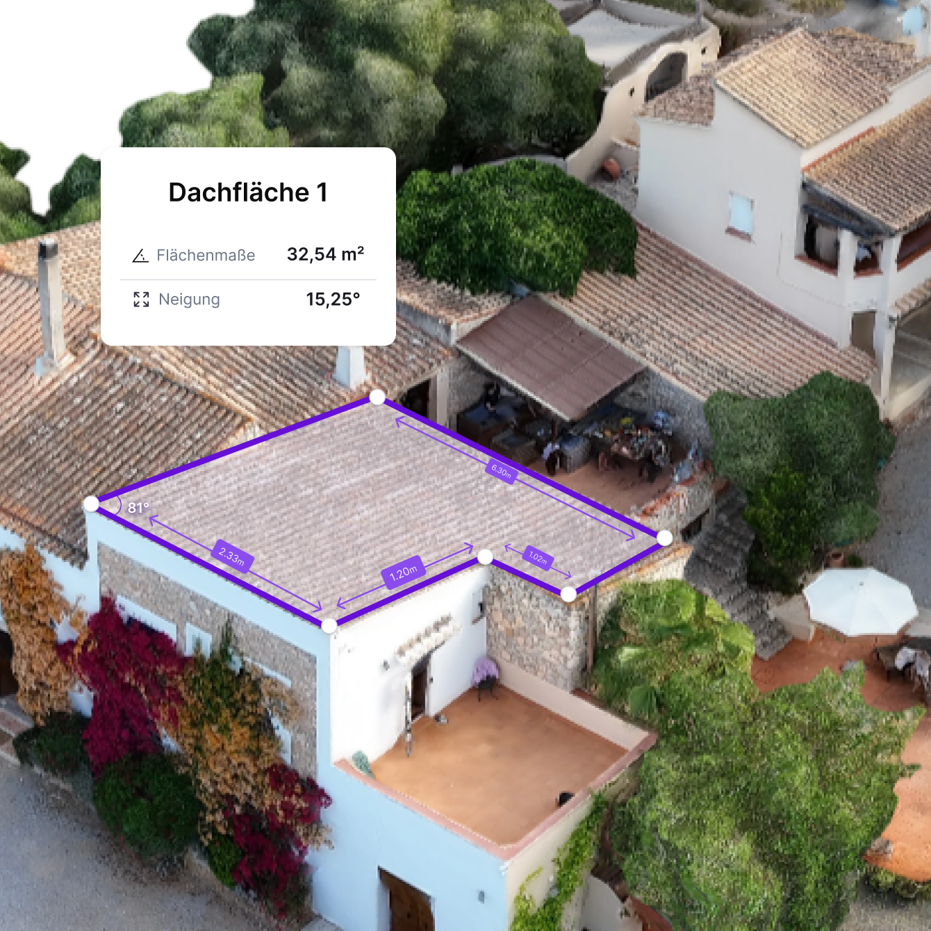
Photogrammetry works by capturing multiple overlapping photographs from different perspectives and processing them through specialised software to create a 3D model. The software identifies distinctive features across the images, creates a point cloud of spatial data, and generates a to-scale 3D model suitable for further planning and analysis.
For building surveying in the UK, the roof, facade, or entire property is photographed using a drone or professional camera. The software recognises common reference points, constructs a three-dimensional point cloud, and produces a precise 3D model that can be used for planning, quoting, and implementation. This approach eliminates the need for manual on-site measurement and reduces project timescales.
What are the Benefits of Photogrammetry for Installers?
Photogrammetry offers installers a practical and cost-effective method for digitally capturing buildings and properties. The primary advantage is eliminating the need for manual on-site measurements, which reduces travel time and project costs. UK heating engineers, PV installers, and builders increasingly rely on photogrammetry for the following reasons:
- Time Savings: A single drone flight captures all necessary data, eliminating multiple site visits. For heating engineers planning heat loss calculations or PV installers assessing roof suitability, photogrammetry reduces on-site time from hours to minutes.
- Accurate Data: Millimetre-accurate 3D models provide the precise measurements needed for heat loss calculations, PV system design, and renovation planning. This accuracy reduces errors in quoting and project implementation.
- Cost-Effectiveness: Fewer site visits mean lower travel costs and reduced project overhead. Processing costs are typically included in the initial survey fee, making the total investment predictable.
- Better Client Communication: 3D models and visualisations help clients understand proposed work, leading to faster decision-making and fewer disputes over quotes.
- Compatibility with UK Software: Photogrammetry data integrates seamlessly with UK-standard CAD software, heat loss calculation tools, and PV design software, streamlining the planning workflow.
- Building Regulations Compliance: Photographic documentation from photogrammetry surveys satisfies Building Regulations Part L requirements for as-built construction details and renovation evidence.
Use Cases: Where is Photogrammetry Used?
In UK trades, photogrammetry is primarily used for projects requiring precise building measurement and digital documentation. The most common applications are:
- Roof Surveys for PV Systems: Photogrammetry is ideal for assessing roof suitability for solar installations. Drones capture high-resolution images, and the resulting 3D model shows roof pitch, orientation, shading, and structural details—all critical for PV system design.
- Construction Progress Monitoring: Developers and contractors use photogrammetry to document construction progress at regular intervals. Monthly 3D models provide visual evidence of work completion and help identify delays or issues early.
- Building Regulations Part L Documentation: New Building Regulations Part L requires photographic evidence of construction details and materials. Photogrammetry surveys provide comprehensive documentation of building fabric, insulation, and construction methods.
- Heat Loss Calculations: For heating engineers, photogrammetry captures room dimensions, window sizes, and building geometry needed for accurate heat loss calculations under BS EN 12831-1:2017 standards.
- Facade and Insulation Planning: Photogrammetry surveys of building facades help plan insulation upgrades, window replacement, or cladding projects by providing precise measurements and visual documentation.
- Heritage Building Assessment: Historic England and conservation specialists use photogrammetry to document heritage buildings before and after renovation work, ensuring compliance with conservation standards.
- Structural Inspections: Photogrammetry allows surveyors to inspect difficult-to-reach areas (steep roofs, tall structures) without scaffolding or access equipment, reducing safety risks and costs.
Other applications outside the trades include archaeological site documentation, agricultural land analysis, and forensic investigation.
What Does Photogrammetry Cost?
Photogrammetry is categorised into three main types based on the camera platform and distance from the subject:
- Aerial Photogrammetry: Uses drones or manned aircraft to capture images from above. This is the most common type in UK construction and is ideal for roof surveys, site mapping, and progress monitoring. Drones must comply with CAA regulations and weigh less than 4kg for most operations.
- Terrestrial Photogrammetry: Conducted from ground level using handheld cameras or tripod-mounted equipment. This method is suitable for facade surveys, building elevations, and detailed structural documentation.
- Close-Range Photogrammetry: Used for smaller objects or building details, often with standard cameras or smartphones. This type is useful for documenting specific building components, damage assessment, or heritage details.
What Types of Photogrammetry are there?
There are three types of photogrammetry: aerial photogrammetry, terrestrial photogrammetry, and close-range photogrammetry. Aerial photogrammetry uses drones or aircraft, terrestrial is done from the ground, and close-range is used for smaller objects or building details—often with a camera or smartphone.
How Accurate is Photogrammetry?
Photogrammetry provides very high accuracy—typically within a few millimetres to centimetres, depending on image quality, camera resolution, and processing software. For building surveys, this level of accuracy is more than sufficient for heat loss calculations, PV system design, and renovation planning.
Professional UK photogrammetry services using high-resolution cameras and advanced processing achieve accuracy suitable for Building Regulations compliance and RICS surveying standards. The accuracy is generally better than manual tape measurements and sufficient for all practical construction applications.
How Many Photos are Needed for Photogrammetry?
For reliable photogrammetry, 30 to 100 overlapping photographs are typically required, depending on the object's size and complexity. For a typical residential roof, 40-60 images are usually sufficient. Larger or more complex sites may require 100+ images.
The key principle is that all areas must be captured from multiple perspectives to ensure the software can accurately reconstruct the 3D geometry. Professional drone operators follow established protocols to ensure adequate image overlap and coverage.
What is Better, Photogrammetry or LiDAR Scan?
Whether photogrammetry or LiDAR is better depends on the application. Photogrammetry provides detailed 3D models based on photos and is ideal for roof and facade surveying. LiDAR scans capture geometry with particular precision and are advantageous for complex interiors.
At autarc, we use photogrammetry specifically for PV planning. You conduct the drone flight, capture the roof, and upload the images. You then receive a 3D model. This is particularly helpful for hard-to-reach or steep roofs.
For heating planning, such as for heat loss calculations or automatic radiator detection, we use the LiDAR scan. This allows for the millimetre-accurate capture of room sizes, window areas, and building structure.
Digitise Your Processes with autarc
Do you install heating systems, solar PV systems, battery storage, or wallboxes? With autarc, you can handle acquisition, planning, funding, maintenance, and client communication in one software. Make your business fit for the future. Register now and test for 14 days for free.